The Geology of the Wye Gorge
Moira Jenkins, 11 April 2012
The talk was introduced as a trip down the Wye Gorge, looking at the rocks and erosional features.
Note that all pictures, except the first, are Copyright of the Hereford and Worcester Earth Heritage Trust.
The trip begins upstream on the Herefordshire plain near Hay-on-Wye, where the River Wye meanders across the soft beds of Raglan Mudstone, the earliest of the Old Red Sandstones. In contrast the high steep sides of the Wye gorge itself show cliffs of resistant Carboniferous limestone.

A useful annotated aerial photograph (above) shows, on the left side, the course of the Wye as it leaves the Herefordshire Plain and cuts into the plateau of the Forest of Dean . A large meander takes the river out again onto the Brownstones of the plain and then back into another gorge section. The Wye here illustrates 'superimposed drainage', which was explained later in the talk.

At the neck of this meander, on the higher harder rocks above the plain, is Symonds Yat Rock. The splendid views from this vantage point show the limestone Coldwell Cliffs to the east (above), the 'Shadowlands' view with Coppets Hill and the Herefordshire Plain opening out to the north, and Symonds Yat West backed by Great Doward to the north west. From river level below the rock at Symonds Yat East, the impressive cliffs and limestone crags are visible. A little further downstream are the remains of the old weir, which provided early water power for small iron industries. Further downstream again is the pedestrian Biblins Bridge with views of the Seven Sisters rocks and interlocking spurs.
The next part of the talk dealt with the sequence of rocks in the region. At Ross-on-Wye, the cliff shows the Brownstones (lower ORS) consisting of varied red sandstones. The upper ORS is represented by Quartz Conglomerate (below), with rounded pebbles brought down by flash floods from the Welsh mountains, and by the Tintern Sandstone.

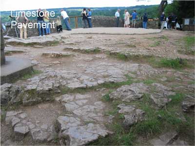
Then a marine transgression at the beginning of the Carboniferous period (c. 340 mya) resulted in varied limestone beds, some containing interesting fossils. The lowest are the Limestone Shales. Next is the Lower Dolomite formed when magnesium replaced some or all of the calcium in the limestone as it was in the process of consolidating. This Dolomitic limestone forms the pavement at Symonds Yat Rock (below).
Next in the sequence is the Crease Limestone (Gully Oolite), oolitic in places, and the site of various caves (see below). Finally the Whitehead Limestone (Llanelly Formation) is a fresh water algal limestone exposed in Lord's Wood Quarry.
When the sea withdrew the Drybrook Sandstone (Cromhall Sandstone Formation) was formed, containing some beds with rounded pebbles, and exposed on the top of Great Doward. Above these sandstones, in an environment of tropical swamps, the Carboniferous coal seams were formed.
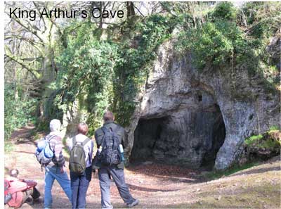
King Arthur's cave (above), along with smaller caves and undercut cliffs, was hollowed out in the Crease Limestone by running water. A valley, now dry, between Little Doward and Great Doward was probably the source of this water during the Pleistocene. Excavations in King Arthur's Cave have revealed bones of mammoth, woolly rhinocerous and other Ice Age mammals, as well as human artefacts.
Just below Little Doward, the course of the Wye returns to the Old Red Sandstones, and the valley widens out. Further downstream, the river enters another gorge section cut in the Carboniferous limestones. Below Tintern the Eagles Nest provides spectacular views (below) to the Severn Estuary, Wintours Leap, Chepstow castle and race-course, and the meanders of the tidal section of the Wye. Vegetation typical of the limestone includes beech and Harts Tongue fern.

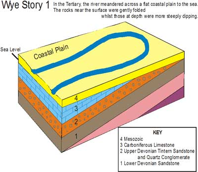
The conclusion of the talk explained the theory of 'superimposed drainage' and the probable origin of the Wye gorges. During the Jurassic and Cretaceous periods, deposits of limestone and chalk probably extended further west than the present Cotswolds, into Wales. These deposits, overlying the dipping Carboniferous beds, formed a coastal plain over which the former River Wye meandered during the Tertiary period (below) .
Later the land rose relative to the sea, and so the river, with increased energy, cut into the rocks over which it flowed. The softer Jurassic and Cretaceous beds were eroded away (below).

Where the river then flowed over hard Carboniferous rocks it cut down into them, so creating the gorges and retaining the meander pattern (below).

During the Ice Age, with the sea level dropping further, and the volume of melt-water periodically increased, the gorges were incised further.
Where the river flowed over the comparatively softer Old Red Sandstones, the meanders were still able to enlarge sideways. Eventually the river was able to cut through the neck of such a meander, leaving it abandoned in the form of an ox-bow which later silted up. Examples are behind Ross-on-Wye (below) and at Newland (between Monmouth and Tintern).

The final picture showed Goodrich castle (below). The Brownstone on which the castle stands was dug out to form the moat and to provide building stones for the main part of the castle. The earlier keep is built of greyer sandstone. It is not known where this stone was quarried – this is the kind of question to be studied by the EHT Building Stones project.
